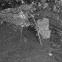
The purpose of this article The devastating major earthquake which occured on December 23, 2003 with a moment magnitude of 6.6, that caused a huge number of human casualties, as well as major destructions in Bam and the surrounding Kerman province in Iran, had been...
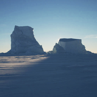
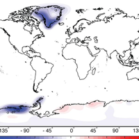
Presentation and introduction to the topic of antarctic ice-mass balances and the improvement of its estimate for the past 5 years. For further reading please see: Sasgen, I.; Konrad, H.; Ivins, E.R.; van den Broeke; M.R.; Bamber, J.L.; Martinec, Z.; Klemann, V.:...
[Updated: 15.08.2012] Finally after 9 month of flighttime, NASA’s mobile laboraty made it to Mars. Carrying the most advanced payload of scientific gear ever used on Mars’ surface, the Mars rover is ready to investigate whether conditions have been...
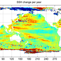
Content: In this project the goal is to retrieve reliable information about the sea level change from 2004 to 2008 using ENVISAT data. Furthermore the main concepts for a software development and implementation shall be simulated. For this purpose a program has to be...
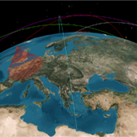
Content: Earth observation satellites have emerged as the preeminent tool for consistent and high-resolution imagery. The eyeON mission is designed to provide rapid on-demand sub three meter resolution imagery as well as generate a database of regions of interest. In...
Content: In the context of a presentation for the ESPACE program at TUM, the GRACE mission and its measurement technique, as well as its use for the geoscientific community for melting land ice oberservations is presented and discussed. For this purpose several...
For the first time, an international team of astronomers have mapped the vertical structure of Uranus’s upper atmosphere, uncovering how temperature and charged particles vary with height across the planet. Using NASA/ESA/CSA James Webb Space Telescope's NIRSpec instrument, the team observed Uranus for nearly a full rotation, detecting the faint glow from molecules high above the […]
Each year, the world’s leading climate scientists evaluate the most critical evidence on how our planet is changing. Their assessments draw heavily on data from Earth-observing satellites – and the latest report delivers a stark warning: the planet’s energy balance is drifting further out of alignment, ocean warming is now accelerating, and the land’s capacity […]
The European Space Agency (ESA) is preparing for the inaugural launch of the Celeste LEO-PNT in-orbit demonstration mission with the first two satellites scheduled to lift off no earlier than 24 March, aboard Rocket Lab’s Electron rocket from the company’s Māhia Launch Complex in New Zealand.
Earth’s river deltas, home to about 5% of the global population and some of the world’s major cities, are experiencing subsidence, which exacerbates the risks from sea-level rise. The Copernicus Sentinel-1 mission has captured a decade's worth of data showing land sinking faster than previously thought.
Zum 34. Mal kamen vom 2. bis 13. September 2019 Wissenschaftler und Ingenieure deutscher Hochschulen und Forschungseinrichtungen ins südfranzösische Bordeaux, um an Bord des europaweit einzigen Parabelflugzeugs A310 ZERO-G unter der "Flagge" des Deutschen Zentrums für Luft- und Raumfahrt (DLR) in Schwerelosigkeit zu arbeiten.
Am 16. September 2019 um voraussichtlich 4:14 Uhr wird die fliegende Sternwarte SOFIA (Stratosphären Observatorium Für Infrarot-Astronomie) – ein Gemeinschaftsprojekt der US-amerikanischen Weltraumbehörde NASA und dem Deutschen Zentrum für Luft- und Raumfahrt (DLR) – auf dem Flughafen Stuttgart landen.
Der Kangerdlugssuaq-Gletscher ist der größte Gletscher an der Südostküste Grönlands und mündet in den gleichnamigen Fjord. Die Gletscherfront, die in der Vergangenheit durch eine sogenannte Eis-Mélange, ein dichtes und starres Paket aus Meereis und gekalbten Eisbergen geschützt war, zieht sich aber zunehmend zurück und der Gletscher kalbt jedes Jahr etwa 24 Kubikkilometer Eis in den […]
Mit der Mission "SOUTHTRAC" (Transport and Composition of the Southern Hemisphere UTLS) erkundet das deutsche Forschungsflugzeug HALO im September und November 2019 die südliche Atmosphäre und ihre Auswirkungen auf den Klimawandel. Das wichtigste Ziel der ersten Kampagnenphase ist die Untersuchung von Schwerewellen an der Südspitze Amerikas und über der Antarktis.
Vein scans and pharmaceutical research topped the science schedule aboard the International Space Station on Wednesday. The Expedition 74 crew rounded out the day with Dragon cargo transfers, lab familiarization activities, and life support maintenance duties.
The seven-member Expedition 74 crew is in its first full week together aboard the International Space Station following Saturday’s arrival of NASA’s SpaceX Crew-12 mission. The orbital septet is resuming its full complement of advanced space science and lab maintenance as the Crew-12 quartet familiarizes itself with station operations.
NASA astronauts Jessica Meir and Jack Hathaway, ESA (European Space Agency) astronaut Sophie Adenot, and Roscosmos cosmonaut Andrey Fedyaev entered the International Space Station at 5 p.m. EST after opening the hatches between the space station and the SpaceX Dragon spacecraft.
NASA astronauts Jessica Meir and Jack Hathaway, ESA (European Space Agency) astronaut Sophie Adenot, and Roscosmos cosmonaut Andrey Fedyaev arrived at the International Space Station as the SpaceX Dragon spacecraft docked with the orbiting complex at 3:15 p.m. EST.
NASA’s live arrival coverage of the agency’s SpaceX Crew-12 mission is underway on NASA+, Amazon Prime, and the agency’s YouTube channel as NASA astronauts Jessica Meir and Jack Hathaway, ESA (European Space Agency) astronaut Sophie Adenot, and Roscosmos cosmonaut Andrey Fedyaev make their way to the International Space Station.
Among the types of Personal Data that this Application collects, by itself or through third parties, there are: first name, last name, email address, Usage Data, username, website and Cookies. Complete details on each type of Personal Data collected are provided in the dedicated sections of this privacy policy or by specific explanation texts displayed prior to the Data collection.
Personal Data may be freely provided by the User, or, in case of Usage Data, collected automatically when using this Application.
Unless specified otherwise, all Data requested by this Application is mandatory and failure to provide this Data may make it impossible for this Application to provide its services. In cases where this Application specifically states that some Data is not mandatory, Users are free not to communicate this Data without consequences to the availability or the functioning of the Service.
Users who are uncertain about which Personal Data is mandatory are welcome to contact the Owner.
Any use of Cookies – or of other tracking tools – by this Application or by the owners of third-party services used by this Application serves the purpose of providing the Service required by the User, in addition to any other purposes described in the present document and in the Cookie Policy, if available. Users are responsible for any third-party Personal Data obtained, published or shared through this Application and confirm that they have the third party’s consent to provide the Data to the Owner.
Mode and place of processing the Data
Methods of processing
The Owner takes appropriate security measures to prevent unauthorized access, disclosure, modification, or unauthorized destruction of the Data.
The Data processing is carried out using computers and/or IT enabled tools, following organizational procedures and modes strictly related to the purposes indicated. In addition to the Owner, in some cases, the Data may be accessible to certain types of persons in charge, involved with the operation of this Application (administration, sales, marketing, legal, system administration) or external parties (such as third-party technical service providers, mail carriers, hosting providers, IT companies, communications agencies) appointed, if necessary, as Data Processors by the Owner. The updated list of these parties may be requested from the Owner at any time.
Legal basis of processing
The Owner may process Personal Data relating to Users if one of the following applies:
Users have given their consent for one or more specific purposes.
Note: Under some legislations the Owner may be allowed to process Personal Data until the User objects to such processing (“opt-out”), without having to rely on consent or any other of the following legal bases. This, however, does not apply, whenever the processing of Personal Data is subject to European data protection law;
provision of Data is necessary for the performance of an agreement with the User and/or for any pre-contractual obligations thereof;
processing is necessary for compliance with a legal obligation to which the Owner is subject;
processing is related to a task that is carried out in the public interest or in the exercise of official authority vested in the Owner;
processing is necessary for the purposes of the legitimate interests pursued by the Owner or by a third party;
In any case, the Owner will gladly help to clarify the specific legal basis that applies to the processing, and in particular whether the provision of Personal Data is a statutory or contractual requirement, or a requirement necessary to enter into a contract.
Place
The Data is processed at the Owner’s operating offices and in any other places where the parties involved in the processing are located. Depending on the User’s location, data transfers may involve transferring the User’s Data to a country other than their own. To find out more about the place of processing of such transferred Data, Users can check the section containing details about the processing of Personal Data. Users are also entitled to learn about the legal basis of Data transfers to a country outside the European Union or to any international organization governed by public international law or set up by two or more countries, such as the UN, and about the security measures taken by the Owner to safeguard their Data. If any such transfer takes place, Users can find out more by checking the relevant sections of this document or inquire with the Owner using the information provided in the contact section.
Retention time
Personal Data shall be processed and stored for as long as required by the purpose they have been collected for. Therefore:
Personal Data collected for purposes related to the performance of a contract between the Owner and the User shall be retained until such contract has been fully performed.
Personal Data collected for the purposes of the Owner’s legitimate interests shall be retained as long as needed to fulfill such purposes. Users may find specific information regarding the legitimate interests pursued by the Owner within the relevant sections of this document or by contacting the Owner.
The Owner may be allowed to retain Personal Data for a longer period whenever the User has given consent to such processing, as long as such consent is not withdrawn. Furthermore, the Owner may be obliged to retain Personal Data for a longer period whenever required to do so for the performance of a legal obligation or upon order of an authority. Once the retention period expires, Personal Data shall be deleted. Therefore, the right to access, the right to erasure, the right to rectification and the right to data portability cannot be enforced after expiration of the retention period.
The purposes of processing
The Data concerning the User is collected to allow the Owner to provide its Services, as well as for the following purposes: SPAM protection, Content commenting, Analytics and Interaction with external social networks and platforms. Users can find further detailed information about such purposes of processing and about the specific Personal Data used for each purpose in the respective sections of this document.
Detailed information on the processing of Personal Data
Personal Data is collected for the following purposes and using the following services:
Google Analytics (Google Inc.)
Comment system managed directly by WordPress
Interaction with external social networks and platforms
Akismet is a SPAM protection service provided by Automattic Inc.
The rights of Users
Users may exercise certain rights regarding their Data processed by the Owner. In particular, Users have the right to do the following:
Withdraw their consent at any time. Users have the right to withdraw consent where they have previously given their consent to the processing of their Personal Data.
Object to processing of their Data. Users have the right to object to the processing of their Data if the processing is carried out on a legal basis other than consent. Further details are provided in the dedicated section below.
Access their Data. Users have the right to learn if Data is being processed by the Owner, obtain disclosure regarding certain aspects of the processing and obtain a copy of the Data undergoing processing.
Verify and seek rectification. Users have the right to verify the accuracy of their Data and ask for it to be updated or corrected.
Restrict the processing of their Data. Users have the right, under certain circumstances, to restrict the processing of their Data. In this case, the Owner will not process their Data for any purpose other than storing it.
Have their Personal Data deleted or otherwise removed. Users have the right, under certain circumstances, to obtain the erasure of their Data from the Owner.
Receive their Data and have it transferred to another controller. Users have the right to receive their Data in a structured, commonly used and machine readable format and, if technically feasible, to have it transmitted to another controller without any hindrance. This provision is applicable provided that the Data is processed by automated means and that the processing is based on the User’s consent, on a contract which the User is part of or on pre-contractual obligations thereof.
Lodge a complaint. Users have the right to bring a claim before their competent data protection authority.
Details about the right to object to processing
Where Personal Data is processed for a public interest, in the exercise of an official authority vested in the Owner or for the purposes of the legitimate interests pursued by the Owner, Users may object to such processing by providing a ground related to their particular situation to justify the objection. Users must know that, however, should their Personal Data be processed for direct marketing purposes, they can object to that processing at any time without providing any justification. To learn, whether the Owner is processing Personal Data for direct marketing purposes, Users may refer to the relevant sections of this document.
How to exercise these rights
Any requests to exercise User rights can be directed to the Owner through the contact details provided in this document. These requests can be exercised free of charge and will be addressed by the Owner as early as possible and always within one month.
Additional information about Data collection and processing
Legal action
The User’s Personal Data may be used for legal purposes by the Owner in Court or in the stages leading to possible legal action arising from improper use of this Application or the related Services. The User declares to be aware that the Owner may be required to reveal personal data upon request of public authorities.
Additional information about User’s Personal Data
In addition to the information contained in this privacy policy, this Application may provide the User with additional and contextual information concerning particular Services or the collection and processing of Personal Data upon request. System logs and maintenance For operation and maintenance purposes, this Application and any third-party services may collect files that record interaction with this Application (System logs) use other Personal Data (such as the IP Address) for this purpose.
Information not contained in this policy
More details concerning the collection or processing of Personal Data may be requested from the Owner at any time. Please see the contact information at the beginning of this document.
How “Do Not Track” requests are handled
This Application does not support “Do Not Track” requests.
To determine whether any of the third-party services it uses honor the “Do Not Track” requests, please read their privacy policies.
Changes to this privacy policy
The Owner reserves the right to make changes to this privacy policy at any time by giving notice to its Users on this page and possibly within this Application and/or – as far as technically and legally feasible – sending a notice to Users via any contact information available to the Owner. It is strongly recommended to check this page often, referring to the date of the last modification listed at the bottom.
Definitions and legal references
Legal information
This privacy statement has been prepared based on provisions of multiple legislations, including Art. 13/14 of Regulation (EU) 2016/679 (General Data Protection Regulation). This privacy policy relates solely to this Application, if not stated otherwise within this document. Latest update: June 28, 2018